Project Configuration
Configuration Description
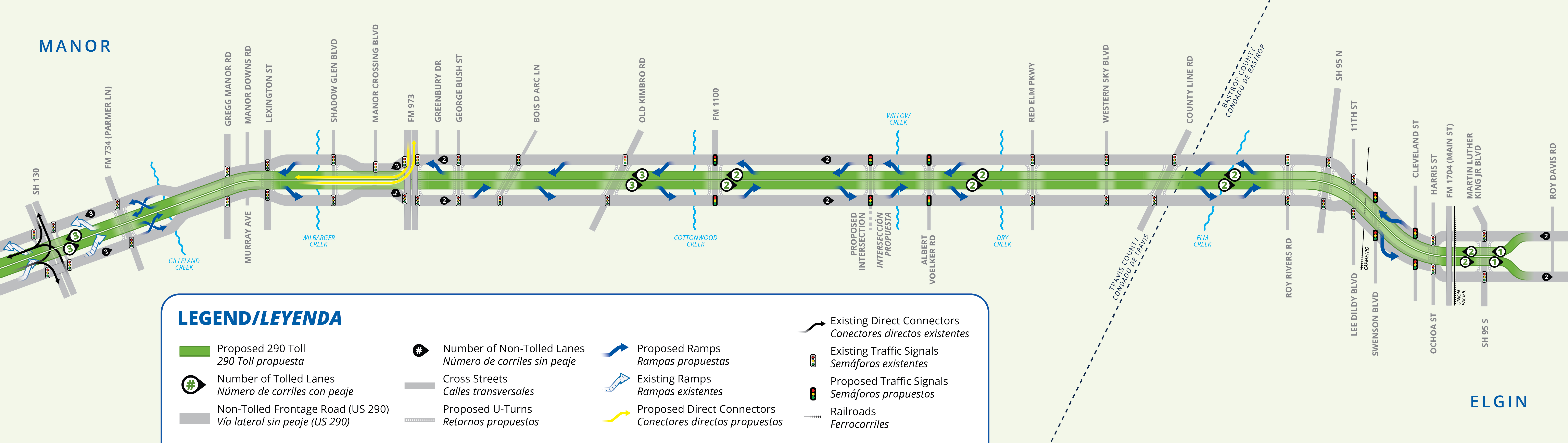
Configuration graphic showing the proposed 290 Toll Extension corridor from SH 130 near Manor on the left side of the image to SH 95 in Elgin on the right. The diagram uses green to represent proposed toll lanes, gray to represent non-tolled US 290 frontage roads, blue arrows to represent proposed ramps, yellow lines to represent proposed direct connectors, black symbols showing the number of non-tolled lanes, and green-and-white symbols with a black outline showing the number of toll lanes.
At the western terminus (or end of the project corridor), the proposed facility ties into the existing 290 Toll road at SH 130. The existing SH 130 interchange includes multiple direct connectors and ramps and currently reduces the tolled mainlanes from three in each direction to two. The proposed project will remove the bottleneck by extending three tolled mainlanes in each direction eastward. The three existing non-tolled frontage road lanes in each direction and existing traffic signals, will for the most part remain unaffected by the project.
The tolled mainlanes cross over Parmer Ln on existing and proposed bridges. East of Parmer Ln, two pairs of braided ramps (one over the other) are proposed in each direction. In the eastbound direction, an exit provides access to Gregg Manor Rd and an entrance carries traffic from Parmer Ln onto the proposed toll road. Conversely, in the westbound direction, an exit provides access to Parmer Ln and an entrance routes traffic from Gregg Manor Rd to the proposed toll lanes. Existing traffic signals at Parmer Ln are unimpacted by proposed improvements.
East of the braided ramps, the corridor crosses Gilleland Creek, where the tolled mainlanes are elevated above the non-tolled frontage roads on a viaduct (an elevated bridge-like structure) from the creek to Lexington St. Three tolled and non-tolled lanes are proposed in each direction in this segment. Gregg Manor Rd and Lexington St will continue to be signalized intersections, with the 290 tolled mainlanes passing over these intersections and U-turn movements provided in the proposed condition.
Eastbound exit and westbound entrance ramps are proposed east of Lexington St to provide access to and from Shadow Glen Blvd. At Wilbarger creek, direct connectors merge and diverge with the tolled mainlanes in the median. They provide direct access to and from FM 973 north of US 290 (i.e. eastbound to northbound and southbound to westbound movements). The tolled mainlanes are once again elevated on a viaduct structure over the frontage roads, going over Shadow Glen Blvd, Manor Crossing Blvd, and FM 973. Three tolled and non-tolled lanes are proposed in each direction and all existing signalized intersections will remain unchanged. At the US 290 and FM 973 interchange, proposed facilities will be stacked vertically from existing ground upwards, as follows: Frontage roads, 290 toll lanes, FM 973 mainlanes, Direct connectors
East of FM 973, three toll lanes are proposed in each direction. Consistent with existing conditions, two non-tolled lanes are proposed in each direction with accommodation for a future potential third lane from FM 973 to County Line Rd. A westbound exit ramp at Greenbury Drive provides access to FM 973. The existing signalized intersection at Greenbury Drive is proposed to be removed and replaced with a right-in/right-out access configuration for both eastbound and westbound traffic movements. A grade separation is proposed at George Bush St with the tolled mainlanes carried over the cross street. The frontage road and cross street intersection will continue to be signalized. East of the intersection, an eastbound entrance ramp provides access to the tolled mainlanes.
Grade separations at Bois D Arc Ln and Old Kimbro Rd carry the tolled mainlanes over each cross street. Between these intersections, eastbound exit and westbound entrance ramps provide access to and from Old Kimbro Rd. Both intersections will remain signalized consistent with existing conditions.
East of Old Kimbro Rd, an eastbound exit ramp reduces the number of tolled mainlanes from three to two, while a westbound entrance ramp adds a third toll lane in that direction. There are thus three toll lanes in each direction west of the ramps and two to the east. Two non-tolled frontage road lanes are maintained in each direction and a uniform cross section of two tolled and two non-tolled lanes per direction are proposed for the remainder of the project. The facilities cross Cottonwood creek at elevations comparable to existing, and approaching FM 1100, the tolled mainlanes begin to elevate as they pass over the intersection. Traffic signals are proposed at the frontage road and FM 1100 intersections.
Continuing eastward, a new (yet to be named) grade separation is proposed adjacent to Ballerstedt Rd. Between FM 1100 and this crossing, eastbound entrance and exit ramps provide access from FM 1100 and to the new intersection. In the westbound direction, exit and entrance ramp provide access to FM 1100 and from the new intersection. The new intersection will be signalized, and two tolled and non-tolled lanes are maintained in each direction.
East of the new intersection, an eastbound entrance and westbound exit ramp provide access from and to the new intersection. All facilities cross Willow Creek at roughly the same elevation as existing, and the tolled mainlanes begin to rise above the frontage roads approaching Albert Voelker Rd to pass over the intersection. Traffic signals are proposed at the frontage road and cross street intersections.
East of Albert Voelker Rd, an eastbound exit and westbound entrance ramp provide access to and from Red Elm Pkwy. After crossing Dry Creek, there are a series of grade separations at Red Elm Pkwy, Western Sky Blvd, and County Line Rd where the tolled mainlanes once again bridge over the cross streets. All three intersections will continue to be signalized similar to existing conditions. The existing signalized intersection at Basket Flower Bend and US 290 is proposed to be removed and replaced with a right-in/right-out access configuration for both eastbound and westbound traffic movements.
Approaching Elgin, eastbound exit and entrance ramps provide access to Roy Rivers Rd and from County Line Rd. In the westbound direction, an entrance ramp from Roy Rivers Rd is followed by an exit to County Line Rd. Between the ramps, all facilities cross Elm Creek at elevations similar to existing. Just west of Roy Rivers Rd, the tolled mainlanes transition onto another extended viaduct spanning over several cross streets and the CapMetro railroad. These cross streets include Roy Rivers Rd, SH 95 North, Lee Dildy Blvd/11th St, Swenson Blvd, and Ochoa St/Harris St. Signalized intersections are maintained at Roy Rivers Rd, SH 95 North, Lee Dildy Blvd/11th St, and Ochoa St/Harris St, while new traffic signals are proposed at Swenson Blvd. As noted previously, two tolled and two non-tolled lanes are maintained through this segment to the end of the project corridor. An eastbound exit and westbound entrance ramp provide access to and from Ochoa St/Harris St.
Immediately east of Ochoa St/Harris St, the tolled mainlane viaduct ends and both the tolled and non-tolled lanes are depressed below the existing FM 1704 (Main St) and Union Pacific Railroad overpasses, matching the existing configuration. East of these crossings, the tolled mainlanes are once again raised to cross over SH 95 South/Martin Luther King Jr. Blvd. The frontage road and cross street intersections will continue to be signalized. Beyond the intersection, approaching the end of the project, the tolled mainlanes transition from two lanes in each direction to one. Finally, west of Roy Davis Rd, the toll road merges into the existing US 290 corridor consisting of two non-tolled lanes in each direction.